V for Van Diemen’s Land

The state I live in is now called Tasmania but was once called Van Diemen’s Land.

The Palawa or Aboriginal Tasmanians were first on this island. When the rising sea level cut off the island from the mainland of Australia, the Palawa were isolated from contact with the aborigines on the mainland.

Their first knowledge of Europeans was when Abel Janzsoon Tasman landed in 1642 and planted a Dutch flag near what is now the town of Dunalley on what was then called Blackman Bay. There was no contact with the aborigines though.

It was at this time the island was named Anthoonij van Diemenslandt (Anthony Van Diemen’s land). This was in honour of the Governor General of the Dutch East Indies.

During the early colonisation of Australia the name Van Diemen’s Land (VDL) was used and it was part of the colony of New South Wales. But in 1825, VDL became a colony in its own right. Then on 1 January 1856, it was renamed Tasmania.

The new name was to celebrate Tasman as the early explorer but also to get rid of the notorious convict past of VDL.

Tasmania 1644

How does VDL relate to my family?

Nearly all my ancestors first arrived when the colony was known as VDL.

Convicts:

  • Francis Colgrave – 1832 – ship Circassian
  • Isabella Watkins(on) – 1841 – Garland Grove
  • John Holliday Boyd – 1836 – Henry Porcher
  • Martha Virco nee Hearn – 1839 – Hindostan
  • John England – 1846 – Pestonjee Bomanjee
  • Rebecca Jackson – 1847 – Waverley
  • William Dawson – 1850 – Maria Somes (2)
  • Catherine McKay – 1848 – Cadet (3)
  • Mathew Sutton – 1840 – Mandarin
  • Mary McCrewney – 1848 – Kinnear (2)

Free settlers:

  • John Davey – 1854 – Wanderer
  • David and Mary Dixon nee Pickering – 1841 – Andromeda
  • William Chandler – 1855 – Fortitude
  • Caroline Bryant – 19 Jan 1856 – La Hogue – would have arrived during celebrations of new name Tasmania
U for Upper Blessington

Upper Blessington is a rural locality about 50 kilometres east of Launceston, Tasmania. There is another locality called Blessington which is about 30 kilometres south east of Launceston and adjacent to Upper Blessington.

In the 2016 census, Upper Blessington had a population of 61 while Blessington had a few more at 93. The two towns are on Blessington Road C401.

Upper Blessington is at the junction to Ben Lomond Road which leads up to the ski resort on Ben Lomond.

Much of the land to the south and east of Blessington Road is now pine plantation rather than the open farmland it was when my ancestors first lived there.

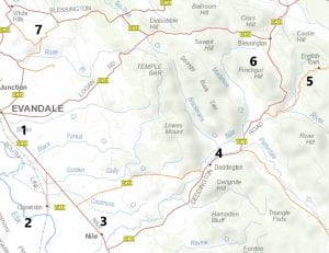
The map below shows the area my family lived in and Upper Blessington is just off the top right corner of the map.

The numbers represent:

          1. Evandale
          2. Clarendon
          3. Nile
          4. Deddington
          5. English Town
          6. Blessington
          7. White Hills

Distance from Evandale to Blessington is approximately 25 kilometres.

My family and the Blessington area

The first two Colgrave generations (18 chn) were born in 5 of the 7 towns above. 1840-1890

The first two Davey generations (20 chn) were born in 5 of the 7 towns  1860-1914

The first Dixon family (5 chn) were born in 2 towns 1842-1850

The first Boyd family (9 chn) were born in 2 towns 1842-1861

No children born at Clarendon in the above numbers.

Evandale – 17, Nile – 4, Deddington – 9, English Town – 5, Blessington – 9 and White Hills area – 8

I drove my mother, her sister and a cousin to Evandale to have a look at the area. We had lunch in the local pub and my cousin called out, “Anyone here a Davey or Colgrave? If so we are your cousins from Hobart.”  We got a positive reply and ended up for afternoon tea and another drive around the area looking at places related to the families.

I also had a big day out in the area as my first trip since Covid began. I wrote a post about it and included images.

I have also run two family reunions in the 1980’s and 2000’s at the Evandale memorial hall for the Davey and Colgrave families. At least 200 people turned up at each reunion where I had my computer to add information but also had a paper copy of the tree put up around three walls of the hall.

T for Thurleigh

Thurleigh is a small village in Bedfordshire, England. In the 2001 census, there were nearly 700 people living there. It is about 10 kilometres north of the main town of Bedford.

Variations in name:

  • Domesday book, it was written as LaLega
  • By 1372 it is Thyrleye
  • In the Deanery of Eaton in 1813, it is finally Thurleigh

In Saxon times, a church and castle were built here as the town was on a plateau about 250 – 270 feet above the surrounding land. Some of the well known buildings are:

  • Blackborne Hall which shows traces of a moat from the original Thurleigh Manor
  • Backnoe End
  • College Farm new house built on old foundations
  • Thurleigh Hall replaced in the 19th century by Whitwick Green Farm
  • a windmill still in use
  • Baptist church from 1888
  • St Peter’s church – oldest part is tower built in the 1130’s

The main occupation in Thurleigh is farming or working in Bedford.

St Peters Church, Thurleigh - geograph.org.uk - 34934

How does Thurleigh fit into my family history?

Back in the 1980’s I was researching some of the convicts in my family in particular my 3x great grandfather Francis Colgrave. He was baptised in Thurleigh on 4 March 1806. I would also research other convicts for people around the world and here is a post about how I found out more about Francis Colgrave back in Thurleigh.

  • 4th great grandfather – also Francis baptised Thurleigh 1771
  • 5th great grandfather – Samuel baptised Bletsoe in 1745 – 3km west from Thurleigh – DNA connections to him
  • 6th great grandfather – Francis baptised Sharnbrook in 1701 – 4km NW of Thurleigh
  • 7th great grandfather – Thomas born in Podington in 1663 – about 7km NW of Sharnbrook

But I need to research further from my 4th great grandfather, as these are details given to me by the researcher in Bedfordshire who also wanted her convict information as a trade for doing the research on my convict.